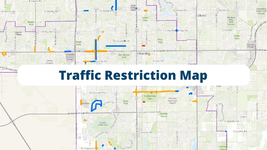
We strive to keep our roads and infrastructure well maintained. For those curious about the road construction or traffic restrictions in the city, you'll find all of the details about current projects.
From design plans and timelines to funding sources and who to contact for more information; we've got you covered.
The Alma School Road Design Concept Report was finalized in July 2019. Three phases of improvements to Alma School Road are planned, as identified in the 10 Year Plan for City Capital Improvements.
Phase One improvements on Alma School Road from Pecos Road to the first median break south of Germann Road were completed in 2021.
Phase Two improvements on Alma School Road are from Germann to Queen Creek roads. Design is scheduled for Fiscal Years 2023-2024 and 2024-2025 and construction is scheduled for Fiscal Year 2025/26. There are currently no road closures or traffic restrictions associated with the project corridor.
Phase Three improvements on Alma School Road are from Chandler Boulevard to Pecos Road. This project is currently outside of the 10-Year CIP.
For more information, visit the Alma School Road project or call the project hotline at 480-898-4060.
Information specifically about the Arizona Avenue Alternatives Analysis Study can be found online by visiting Valley Metro, or calling Victoria Bray at 602-490-8284.
The City is planning to widen Chandler Heights Road between Gilbert Road and Val Vista Drive. Construction is currently scheduled to begin in early 2025.
The project will widen the two-lane road to four lanes (two lanes in each direction) with raised medians, bike lanes, center turn lane, curb, gutter, sidewalk, street lighting and drainage improvements. A public meeting was held Nov. 14, 2018 to discuss the project and obtain community input.
For more information, visit Chandler Heights Road Improvement Project: Gilbert Road to Val Vista Drive or call the project hotline at 480-898-4060.
A storm drain, water and sewer improvement project is underway in the Detroit Basin/Gazelle Meadows Park area. This project is jointly funded by the City of Chandler and the Flood Control District of Maricopa County.
Construction is currently underway and more details are available at the Detroit Basin and Erie Street Improvements or by contacting the project hotline at 480-898-4060.
ST2007.401
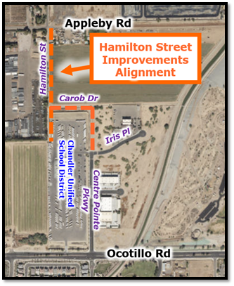
The City of Chandler, in partnership with Chandler Unified School District (CUSD), has contracted with Redpoint Contracting to construct Hamilton Street to complete the connection between Appleby Road and Ocotillo Road, and also provide better access for CUSD Transportation.
When complete, the future Hamilton Street from Appleby Road south will connect to the future Carob Drive to the east and south to Centre Pointe Parkway at Iris Place. The road will be constructed as a two-lane roadway with curb, gutter, sidewalk and streetlights, and includes undergrounding the SRP irrigation ditch along the alignment, installation of waterline, and utility work to accommodate the improvements.
Access will be maintained to businesses during this work, which will primarily take place weekdays, during daytime hours. Project completion is slated for Fall 2025. Thank you for your patience during this work.
Project Info: 480-898-4060
This project consists of widening Lindsay Road, from approximately 600 feet north of Ocotillo Road to Hunt Highway, with four through lanes (two through lanes in the northbound and southbound directions), as a minor arterial standard with 55' on each side.
This project will complete the gaps of missing arterial roadway improvements between developed communities. Improvements include new pavement, raised landscaped medians, bike lanes, center turn lane, curb, gutter, sidewalk, Americans with Disabilities Act upgrades, street lighting, drainage infrastructure, communication and traffic signal infrastructure, utility relocations, landscaping and fence restoration, and traffic signal upgrades and dual left turn lanes at intersection of Lindsay Road and Riggs Road. The project includes drainage improvements such as retention basins and concrete scuppers to accommodate future drainage needs in the project area. In addition, there will be improvements to traffic signals and the traffic signal interconnect, as well as new LED street lighting and conversion of overhead electrical SRP 12kV Overhead Power to underground.
For more information, visit Lindsay Road Project or call the Project Hotline at 480-898-4060.
Stay informed as the Arizona Department of Transportation (ADOT) makes improvements to the Loop 202 Santan Freeway. The project has begun, and it is scheduled for completion in 2027.
Major elements of the project include:
- Add two lanes in each direction between Price Rd. and Gilbert Rd.
- Add one lane in each direction between Gilbert Rd. and Val Vista Dr.
- Widen Loop 202 freeway entrance and exit ramps
- Widen bridges over Arizona Ave., Union Pacific Railroad and Consolidated Canal
As the Loop 202 ramps are widened, the entrance and exit ramps may close for up to 60 consecutive days. ADOT will stagger this work to avoid closing consecutive freeway entrance or exit ramps in the same direction. This portion of the project is planned to begin in 2025.
Two ramps connecting the Loop 101 and Loop 202 freeways also may close for up to 15 consecutive days as improvements are made. Ramps connecting southbound Loop 101 to eastbound Loop 202 and westbound Loop 202 to northbound Loop 101 may be affected at different times in 2025.
The City of Chandler has contracted with Kimley-Horn to conduct a preliminary design study of the McQueen Rd. corridor from Warner Rd. to Pecos Rd. The goal of the study is to provide alternatives and recommendations to improve McQueen Rd. to the city’s major arterial standard, with three travel lanes in each direction.
The City of Chandler is conducting a 9-month study to evaluate the feasibility of upgrading existing bike lanes to protected bike lanes on arterials and collectors.
This project will analyze both existing and planned bike lanes on arterial and collector streets and determine which bike lanes could be converted to protected lanes without removing a vehicle lane or widening the roadway.
This final report will include:
- protected bike lane design criteria,
- determine the feasibility of converting existing and planned bike lanes to protected bike lanes in the City of Chandler, and
- develop a prioritized list of locations for implementation.
For more information, visit Protected Bike Lane Feasibility Study.
The City of Chandler has contracted with Kimley-Horn to design improvements to reduce traffic congestion and improve safety at the Ray Road and Dobson Road intersection. Improvements include adding dedicated right turn lanes, dual left turn lanes, raised median islands and bike lanes to complete all four approaches to the intersection, as well as curb, gutter and sidewalk. The existing six through lanes (three in each direction) on Dobson Road and four through lanes (two in each direction) on Ray Road will be maintained.
In addition, there will be traffic signal improvements, ADA improvements, asphalt pavement rehabilitation, upgraded street lighting, drainage improvements and associated utility relocations for the project.
The project is receiving federal funds for design with construction currently scheduled to begin in the summer of 2026.
For more information, visit Ray & Dobson Roads Intersection Improvements.
The City of Chandler has contracted with B&F Contracting to rehabilitate the sewer pipeline in Price Rd, from south of the Loop 202 to Queen Creek Rd. The “trenchless” technology of lining the sewer pipeline extends the life of the sewer pipeline and is less impactful and of shorter duration than removal and replacement.
For more information, visit: Sewer Manhole & Pipeline Rehab Projects
The City of Chandler contracted with Achen-Gardner Construction to replace water pipeline, associated residential service connections, and fire hydrants in Tyson Manor, Sunset Manor and Arrowhead Meadows neighborhoods in Chandler. Construction is scheduled to begin in Spring 2025 and take approximately 12-14 months to complete.
See a project map and learn more details on the Water Main Replacements Project call the Project Hotline at 480-898-4060.
Valley Freeway Construction
State Road Conditions and
Traffic Advisories
Waze
The city partners with Waze to enable Chandler road restrictions to appear on their app. Chandler's information is available online via Waze Live Map or by downloading the Waze app.
For Contractors: Road Projects and Traffic Restriction Information |
